Debatable Land between England and Scotland
Date:
1552
Reference:
MPF 1/257
Creator:
Maps and plans extracted to flat storage from records of the State Paper Office
Catalogue context:
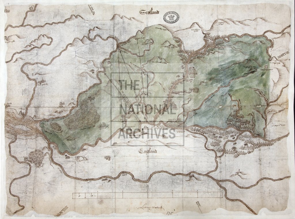
1 item extracted from SP 50/5 (folio 175). England-Scotland boundary. 'The Plan of the Debatable Land between England and Scotland' (endorsement): map of land on the Cumberland-Dumfriesshire border in dispute, covering about ten square miles. Shows Liddesdale, Nicholl Forest, towns, rivers, forests, hills, mosses, a standing stone. Buildings drawn in simple elevation. Elementary hill-shading. Scale bar: 2 inches to 1 mile. An early example of a map drawn to scale, although Tyacke and Huddy (p15) suggest that a customary mile may have been used, rather than the standard mile. Drawn and signed by Henry Bullock, subsequently Master Mason of the King's Works. Cardinal points set diagonally in margins. Oriented to the north-west. To illustrate proposals by the parties and agreement reached on the question of the Anglo-Scottish border. Four lines show: the Scottish offer, the French ambassador's and the English commissioners' proposals, and the boundary agreed between the parties on 24 September 1552. Enclosure...
Categories:
Maps and plans
Subjects:
Archives and libraries; Forestry; Maps and plans
Topics:
Agriculture and environment; Land and buildings
Period:
Early Modern
Places:
England; Great Britain; Scotland
Copyright information:
Copyright clearance for publication is not required, except in the case of documents in third-party copyright.
Usage terms:
https://www.nationalarchives.gov.uk/documents/information-management/use-of-tna-materials.pdf