Manchester Ship Canal
Date:
1925
Reference:
RAIL 1029/89
Creator:
Pre-nationalisation railway companies, pre-nationalisation canal and related companies, the London Passenger Transport Board, and successors
Catalogue context:
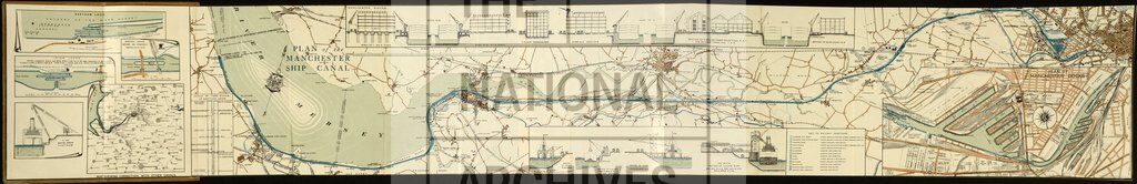
'Plan of the Manchester Ship Canal': diagrammatic map of the whole length of the canal, its connections with other waterways, and the locations of docks, locks, wharves, coal hoists, etc. Reference table to railway junctions with companies named. Scale: 1 inch to 625 feet. Compass indicator. Lithographed by George Falkner & Sons Ltd, Manchester. Insets: enlarged plan of Manchester Docks with individual dimensions; elevations and sections through warehouses; sections of lay-bys and basins, etc. House advertisement on the dorse. The cover bears a Manchester Ship Canal Company label with a note stating: 'with compliments of Mr.K.R. Brady, of the Publicity Department'.
Categories:
Maps and plans
Subjects:
Railways
Topics:
Land and buildings; Transport and travel
Period:
Interwar
Places:
Manchester
Copyright information:
The National Archives understands this item to be the copyright of the British Transport Commission and British Railways Board. It may not be reproduced except with the permission of the copyright owner. Contact details for seeking that permission can be found in the Usage terms.
Usage terms:
https://www.nationalarchives.gov.uk/documents/information-management/use-of-tna-materials.pdf