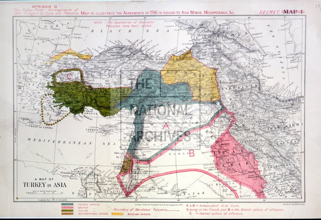
The Sykes-Picot Agreement of 1916 in regard to Syria & Palestine.
Date:
1916
Reference:
MFQ 1/388/2
Creator:
Maps and plans extracted to flat storage from records of various departments held at the Public Record Office, Kew
Catalogue context:
2 items (appendices I-II to a memorandum, 24 October 1930, on the exclusion of Palestine from the area assigned for Arab independence by the McMahon-Hussein correspondence of 1915-1916) extracted from CO 733/178/5 . Middle East. (1) 'Pre-war Turkish administrative districts comprised in Syria and Palestine': map of the area between Alexandretta (now Iksenderun, Turkey) and Aqaba (now in Jordan), also showing the Hejaz railway. Scale: 1 inch to about 47 miles. Overprinting, coloured, showing the boundaries of mandated Palestine. (2) 'A map of Turkey in Asia': covering the area between Nis (now in Serbia), Alexandria (Egypt), the Persian Gulf, and the Caspian Sea. Scale: 1 inch to about 205 miles (calculated). [By] Stanford's Geographical Establishment. Overprinted titles: 'Map to illustrate the agreements of 1916 in regard to Asia Minor, Mesopotamia etc'; 'The Sykes-Picot Arrangement of 1916 in regard to Syria and Palestine'; overprinting, coloured, showing independent Arab states and British, French, Ital...
Categories:
First World War; Overseas
Subjects:
Archives and libraries; Asia; Conflict; Europe and Russia; Maps and plans; Middle East; Operations, battles and campaigns; Railways
Topics:
International trade and affairs; Land and buildings; Military and war; Transport and travel
Period:
Early 20th Century
Places:
Palestine
Copyright information:
Copyright clearance for publication is not required, except in the case of documents in third-party copyright.
Usage terms:
https://www.nationalarchives.gov.uk/documents/information-management/use-of-tna-materials.pdf