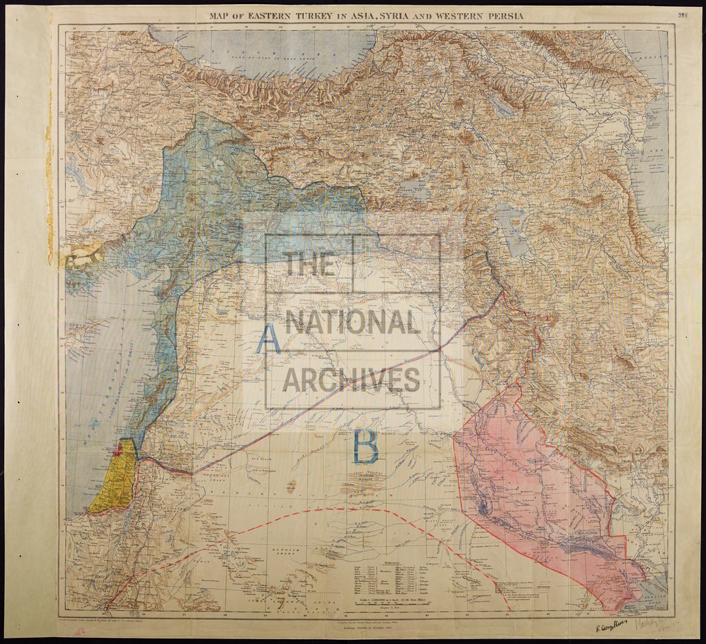
Sykes-Picot Agreement, Eastern Turkey in Asia, Syria and Western Persia
Date:
8 May 1916
Reference:
MPK 1/426
Creator:
Maps and plans extracted to flat storage from records of the Foreign Office
Catalogue context:
1 item (enclosure in Paul Cambon's letter to Sir Edward Grey, 9 May 1916) extracted from FO 371/2777 (folio 398). Middle East. 'Map of Eastern Turkey in Asia, Syria and Western Persia': showing mountains, defiles, rivers, lakes, swamps, seas, wadis, ancient canals (dry), the Jordan Depression, towns, villages, castles, bridges, principal routes, railways, telegraph lines, and boundaries, including the approximate boundary between Persian and Turkish territory; (covering territory now chiefly in Iran, Iraq, Syria and Turkey). Reference tables; list of place name elements. Conical projection with standard parallels at approximately 32° and 40°[E]. Published by the Royal Geographical Society, 1910; railways added to November 1915. MS additions, coloured, showing proposed administration, including British and French spheres of influence, independent Arab States, and the 'Sykes-Picot Line'. Signed: Sir Mark Sykes and Fr[ançois] Georges-Picot, 8 May 1916. Mr Cambon's letter was subsequently print...
Categories:
First World War
Subjects:
Archives and libraries; Asia; Communications; International; Maps and plans; Middle East; Railways
Topics:
Arts and culture; International trade and affairs; Land and buildings; Military and war; Transport and travel
Period:
Early 20th Century
Copyright information:
Copyright clearance for publication is not required, except in the case of documents in third-party copyright.
Usage terms:
https://www.nationalarchives.gov.uk/documents/information-management/use-of-tna-materials.pdf